

A gathering of between 80 and 100 people turned out for a meeting hosted by Save Minster Marshes group in Cliffsend this week and heard about plans to use the former hoverport as a storage base.
The campaign group is working to raise awareness of the National Grid plans to build a converter station and infrastructure at Minster Marshes which, they say, will destroy wildlife and cause noise and light pollution.
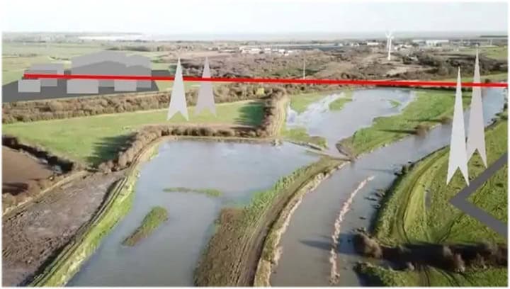
The meeting at Cliffsend Village Hall on Thursday (July 25) began with a presentation by nature enthusiast Nik Mitchell which outlined the 9 hectare development which fellow campaigner George Cooper said would stand almost 100ft tall and take up land equal to the size of 22 football pitches.
The Sea Link project involves creating a subsea electricity cable between Suffolk and Kent which National Grid says will help deliver the UK’s energy security strategy and net zero targets.
The proposals outline a preferred route of 10km of onshore and 140km of undersea cables, together with potential landfall and converter station locations at Friston substation in Suffolk and at Richborough.
National Grid’s preferred route runs from a landfall in Pegwell Bay to the proposed converter station site and high voltage pylons over the land to the south of Minster.
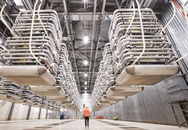
The converter station, which will be up to 28 m high plus external equipment -such as lightning protection, safety rails for maintenance works, ventilation equipment, aerials, and similar small scale operational plant, or other roof treatment- will also include a new substation immediately adjacent.
The company says that following statutory consultation between October and December 2023 and reviewing the feedback a series of changes have been made to the proposals.
One of those changes has been identifying a further construction and maintenance access route off Sandwich Road via the former hoverport along with changes to construction, compounds, and temporary overhead line diversions.
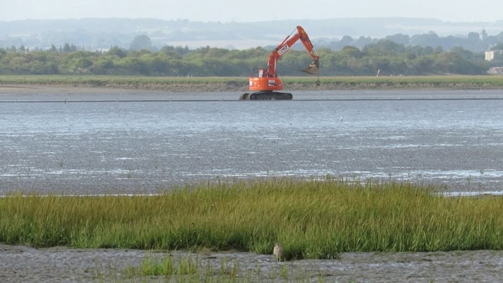
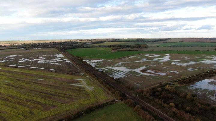
Nik told the meeting that cable will run through a Site of Special Scientific Interest (SSSI) at Pegwell with diggers being used on areas which currently people are not even allowed to walk on.
National Grid says the majority of cables will be constructed using standard open cable trenches. This construction method involves digging trenches, laying the cable ducts within these trenches and then re-covering the trenches (using the original topsoil and subsoil, where possible) before reinstating the land. They would then pull cables through the previously-installed ducts at a later date.
Around the landfall point at Pegwell Bay, they are proposing to use a trenchless construction method to lay the underground cables. This would involve installing an underground duct or pipe between an onshore transition joint bay (where two sections of cable are connected together) and a point offshore. This approach does not require the removal of the topsoil or subsoil and minimises disruption at the surface, such as within Pegwell Bay.
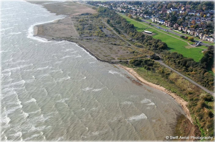
National Grid says that to “avoid using the saltmarsh as an access route” they would instead have a new construction and maintenance access off Sandwich Road via the former hoverport in Pegwell Bay. This includes a compound off Sandwich Road.
Nik said: “The hoverport is a really special place, a biodiversity hotspot. They refer to it as an abandoned car park. If it goes ahead there will be footpaths and roads closed, storage facilities at the hoverport and they will be using heavy machinery. It is very likely that no-one will be allowed down to the hoverport, it will be closed and they will be driving machinery off the apron and onto Pegwell Bay.”
The meeting heard that vehicles may include those used to transport transformers such in 2017 to Richborough for the Nemo Link project – the laying of high voltage electricity cables under the sea between the former Ricborough Towers site and Herdersbrug in Belgium.
Nik said the driving of machinery on the hoverport, which opened in 1969, would likely have an impact as the site was built on colliery waste which is now coming closer to the surface as the concrete breaks up.
Wildlife in the area includes bats, birds and several varieties of orchid.
Other changes causing concerns include the siting of six temporary pylons, which will still need hard standing and require heavy machinery which will disrupt the marshland.
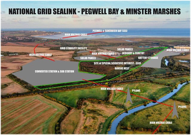
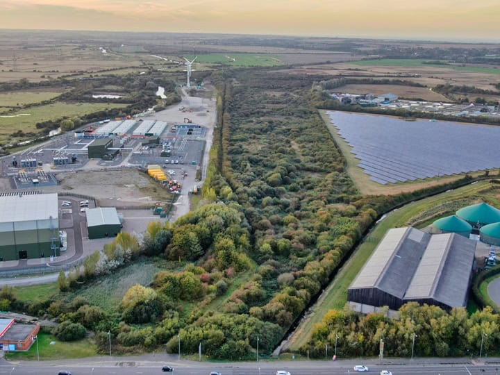
Cumulative impact was also discussed with the SSSI site becoming surrounded by the proposed converter station and pylons plus existing solar panel and battery storage sites and planned sewage treatment expansion works.
Noise, run off pollution, light pollution from the existing Nemo site and bird strikes at pylon areas were discussed as well as the impact on species in the area which include water voles, beavers, Ravens, Peregrine falcons, Nightingales, Turtledoves and more.
The extended height of the station and the use of pilings across the marsh is also a concern.
SMM founder George Cooper said this would likely require some 360,000 tonnes of aggregate involving 16000 lorry movements to transport it, possibly from Ramsgate harbour where Brett Aggregates operates to the marsh.
SMM say alternative sites should be looked at, saying it is not a consultation if there is only one choice of site for the National Grid project. One suggestion was building the converter offshore as has been done in Belgium.
The Sea Link project needs to obtain a development consent order (DCO) via an application to the Planning Inspectorate.
The development consent being sought will include a number of other provisions, including those which authorise the compulsory acquisition of land, and the compulsory acquisition of rights in, on or over land, if necessary, to construct, operate and maintain the proposed project.
The Secretary of State is expected to make a decision in 2025 with construction then taking place, if granted, between 2026 and 2030.
Changes to construction times mean it will be able to run seven days a week, including Bank Holidays if necessary.
County Councillor Karen Constantine, who is one of the representatives for Ramsgate, said: “The development is very concerning; the scale of the project and the duration of the build are rightly alarming, especially to the residents who live nearby. Completion may be scheduled for 2030 – but I fear it could take longer.
“I recently met virtually with National Grid and was able to reiterate and reinforce the concerns of our redoubtable campaigners who are, rightly, attempting to hold National Grid to account.
“In particular I support wildlife campaigner Nik Mitchell’s call’s for any mitigations to protect wildlife to be commenced prior to the earth works and build. This will give wildlife and valuable ecology an opportunity to become established. This must be done if National Grid are to demonstrate their positive intentions to both wildlife and the residents impacted. I have requested these processes be built into the timeline and for a formal written outline. I await confirmation.
“If this project must go ahead, I sincerely hope National Grid are listening and that they take the action they have agreed to.”
What has changed?
Permanent infrastructure HVDC cable route
Realigned high voltage direct current (HVDC) cable route near the A256 to avoid existing buried water infrastructure in this area. The use of trenchless crossing technology to reduce the impact of construction activity on road users.
Converter station height
Following more detailed design work after completing site surveys, National Grid is proposing to increase the ground level at the converter site around the converter station height by constructing a stone platform of up to two metres. The work may need to involve installing modular columns, which are underground concrete supports approximately 20 metres deep that help to spread the weight of buildings above, or by piling into the bedrock below. The approach taken will depend on ongoing and future detailed survey work.
The maximum height of the converter station buildings themselves would not change. However, as these structures would now be on a raised platform, the maximum total height will now be 28 metres rather than 26 metres.
Location and type of new pylons
Of the options consulted on previously, National Grid is confirming the use of full-height (approximately 50 metre) lattice pylons for the connection between the proposed combined converter station/substation and the Richborough to Canterbury 400 kV overhead line.
This means there would be fewer new pylons in total when compared to the low-height pylon option.
The location of the pylons now reduces the size of the triangular area that would be formed by the construction of pylons between the existing overhead line and the proposed substation. This aims to reduce the risk that birds could become trapped in between the new and existing overhead lines, but would result in an increase of approximately 1.2 km in the total length of new overhead line compared to original proposals at statutory consultation.
Have you say
Between now and 11 August, consultees will be able to provide feedback on the changes, or on the proposals more generally.
Details can be found at nationalgrid.com/sealink.
Paper copies
Paper copies of consultation material available at the following locations
Ash Library 11 Queen’s Rd, Ash, Canterbury
- Minster Library 4a Monkton Rd, Minster,
- Sandwich Library 13 Market St, Sandwich
- Ramsgate Library Guildford Lawn, Ramsgate
- Newington Library Royal Harbour Academy, Stirling Way, Ramsgate
- Margate Library Cecil Street, Margate,
Feedback – submit comments by 23:59 on 11 August.
Email: [email protected]
Write to: FREEPOST Sea Link
