


An outline proposal for 450 homes on arable land in Margate will be considered by councillors on the authority’s planning committee.
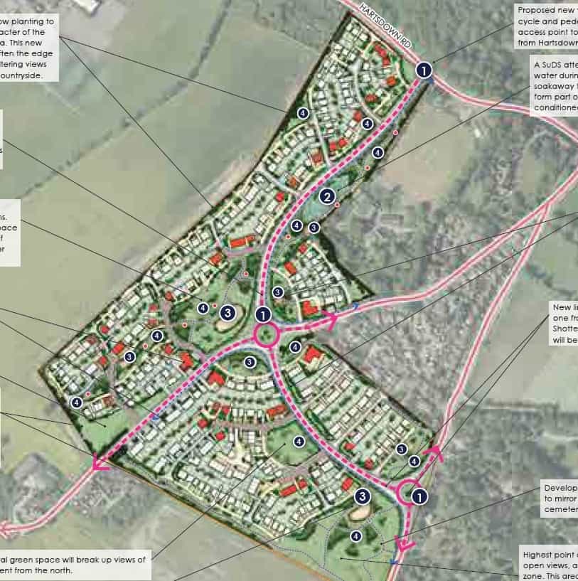
Gladman Developments Ltd propose to build the homes, a new distributor link road connecting Hartsdown Road, Shottendane Road and Manston Road, two new roundabouts, public children’s play areas and recreational routes.
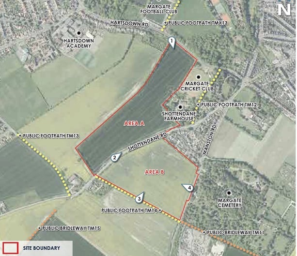
The 19.53ha site is made up of two arable fields -Tyrells’s Top and Tyrell’s Bottom – either side of Shottendane Road.Wheat is cultivated on the land.
Gladman says the site will have up to 450 homes of varying sizes, types and tenures, the new distributor link road connecting Hartsdown Road, Shottendane Road and Manston Road to relieve pressure on the surrounding road network and access for vehicles, pedestrians and cyclists from Shottendane Road and Manston Road,from two new roundabouts.
A retention of the majority of trees and hedgerows along the boundary is pledged as well as landscaped open spaces for children’s play areas.
In the application the developer says: “A large new linear park is proposed within the northern part of the Site. This will be planted with native tree species of local provenance to reflect and restore elements of the local landscape character.
“Recreational paths will be provided around the new housing and through the public open spaces, providing an informal recreational resource within the development. A new cycleway will also be provided through the development alongside the distributor road, which will link Hartsdown Rood with Manston Road, avoiding the busy junction.”
But the contentious plan has provoked more than 50 objections from residents and bodies including Thanet Campaign for the Protection of Rural England (CPRE) which says Thanet has an impractical and unsustainable target for housing and the Local Plan needs an early radical review, which cannot be done whilst there is uncertainty about Manston airport. The group also raises the issue that only 10% affordable housing is pledged rather than 30%.
Margate Civic Society has also objected on grounds including traffic congestion and the loss of prime agricultural land.
The application has been called to Planning Committee by Cllr Candy Gregory on the grounds of loss of farmland, highway safety and capacity issues, impact on community facilities and flood risk.
Thanet council’s planning report says that planning policy not to grant significant developments on agricultural land unless “the benefits of the proposed development outweigh the harm resulting from the loss of agricultural land” do not apply to the Shottendane build.
The report states: “The application site comprises undeveloped greenfield land, still actively in use for agricultural purposes. A series of soil tests were undertaken by the applicants and confirms that 50% of the site is grade 3a, 49% grade 3b and 1% non agricultural.
“Given this only 50% of the application site comprises best and most versatile agricultural land. The site is a Strategic Allocation for residential development in the Local Plan where the loss of agricultural land has been considered and weighed against the need for housing through the policy process. Therefore policy E16 does not apply to this proposal, and the general presumption to safeguard best and most versatile agricultural land does not apply to this site.”
A report to councillors also highlights the need to protect areas of archaeological importance, saying: “The south eastern area of the site includes the remains of a Bronze Age barrow cemetery which was later the focus of an early medieval cemetery. The presence of a ring ditch and one burial was picked up in the evaluation.
“The barrow cemetery and the main part of the medieval cemetery lies on the south boundary. A Neolithic pit was also found during evaluation trenching in the south eastern area of the site. Although undesignated the archaeological remains in the south eastern area of the site can be considered of a significance that merits preservation in-situ.
“Archaeological remains elsewhere within the development site include a small group of pits of possible Neolithic date and an enclosure and field boundaries of Iron Age date. The site also included evidence of the former brickworks and brickearth extraction.”
The developer has outlined a proposal to preserve the archaeology in the south eastern part of the site.
They also claim the development “would contribute to the economic role of the area by generating employment and tax receipts during construction. In the longer term the local economy would benefit from the provision of housing for workers, investment in local infrastructure and services, additional expenditure on goods and services, and funds from the New Homes Bonus and from additional Council Tax receipts.”
A developer profit allowance of 17.5% of GDV of the market housing and 6% on the affordable housing has been assumed within the viability report, with a total profit of £19,522,010.
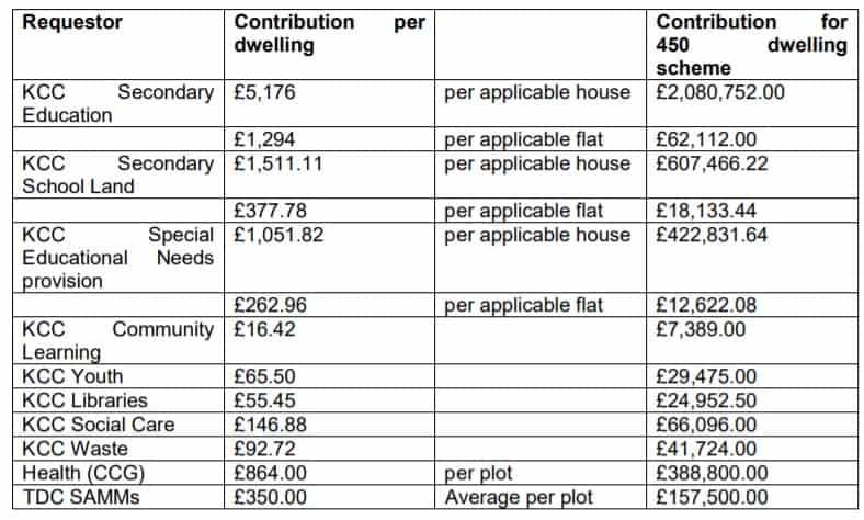
As part of the plans the developer will be expected to pay:
It has been recommended that councillors delegate the decision for planning officers to agree.
The report says: “The provision of up to 450 dwellings would make a significant contribution to the District’s Housing supply, supporting the economic and social dimensions of sustainable development, with employment provided through construction of the site. This contribution to supply should be given great weight given that the Council has not met the Housing Delivery test.
“The provision of the link road from Manston Road to Hartsdown Road will provide clear and demonstrable benefits to the district’s transportation network, whilst accommodating additional traffic created from the proposal. Whilst below the policy requirement, the proposal will also provide social benefit through 10% on site affordable housing provision and the creation of a contribution pot to facilitate the delivery of both community and highways projects in the district
“The development would result in the loss of agricultural land and countryside, however, this has been agreed through the Local Plan adoption process. The amount of development proposed on the site can be accommodated without resulting in significant harm to the character and appearance of the area, and in principle the development will not result in significant harm to the living conditions of surrounding residential occupiers
“Specific measures with regard to surface and foul drainage, archaeology, contamination, ecology will be secured
“It is recommended the Members defer and delegate the application to officers for approval, subject to the receipt of a satisfactory Section 106 agreement to secure the required planning obligations within 6 months of this resolution.”
Councillors will discuss the plan at a meeting on April 21.
