

People wishing to submit views on National Grid’s Sea Link project application are faced with 408 documents, comprising thousands of pages, outlining the company’s plans.
Sea Link is a 2 gigawatt (GW) high voltage direct current (HVDC) cable between Suffolk and Thanet. It is approximately 138 kilometres (km) long with cable at sea and also at landfall.
To bring the power from the subsea cables into and out of the electricity network there will be converter stations, substations and new underground and overhead electricity lines at both ends.
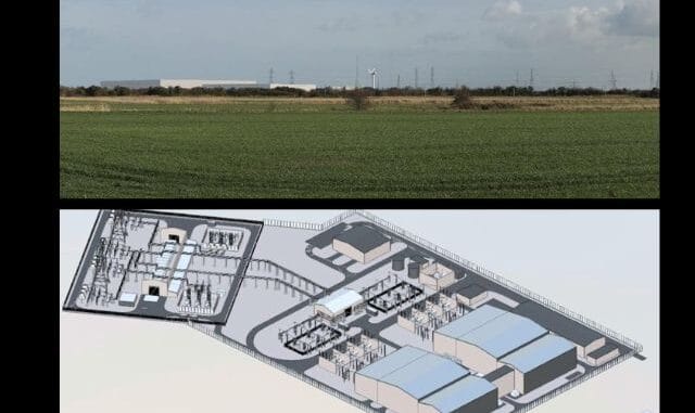
Among the documents submitted is a 3D view of the proposed converter station and substation planned on Minster Marshes, adjacent to the protected Sandwich and Pegwell Bay National Nature Reserve.

Kent Wildlife Trust says the development would result in the loss of 13.6 hectares of valuable habitat within Minster Marshes, “posing significant threats to local biodiversity.”
National Grid says demand for energy is increasing and the Sea Link project is designed to deliver renewable and low carbon energy efficiently to homes and businesses across the regions and beyond.
The company say the existing electricity network in Suffolk and Kent needs upgrading because the UK’s electricity grid was originally built in the 1960s to connect electricity generated in power stations from fossil fuels.
Documents outlining the Thanet end of the scheme say it will comprise of:
- A landfall point at Pegwell Bay.
- A Transition Joint Bay (TJB) – an underground, concrete box structure where the offshore cable connects to the onshore cable – connecting to cable the converter station.
- A 2 GW HVDC converter station (including a new permanent access off the A256), up to 28 m high plus external equipment (such as lightning protection, safety rails for maintenance works, ventilation equipment, aerials, and similar small scale operational plant) and a new substation at Minster Marshes.
- Removal of approximately 2.2 km of existing overhead line, and installation of two sections of new overhead line, together totalling approximately 3.5 km, each connecting from the substation near Minster and the existing Richborough to Canterbury overhead line.
National Grid says the total land needed for the substation and converter station would be approximately 9 ha.

The converter station will comprise of a DC hall, converter transformers, valve hall, reactor hall, AC switchyard, control building, strategic spare parts building, LV electricity supply, fire deluge pump house, car parking, a permanent access road and landscaping.
Permanent access to Minster 400 kV substation and Minster Converter Station will be via a new access point off the A256, north of Jutes Lane. The site will have external lighting.
The construction of the proposed converter stations would take approximately four years from first site access to reinstatement, excluding ongoing landscaping monitoring or maintenance
An indicative timeline says, subject to gaining development consent, construction works would be expected to start in 2026 and be completed by the end of 2031 with reinstatement potentially continuing into 2032.
The peak construction workforce in Kent would be approximately 241 with work scheduled to take place 7 days a week, including bank holidays, from 7am to 7pm weekdays and 7am to 5pm weekends/bank holidays.
Documents say work would include ground improvement involving the excavation and replacement of soft ground – estimated at 250,000 m3 of fill and approximately 40,000 m3 of cut (soil removed from higher areas of a site), to create a platform on which the sub station and converter station would be built.
Stone haul roads will also be created.
Construction access, which will mean thousands of vehicle trips, will include:
- A256 Northbound Carriageway: Main access during both construction (for mobilisation/trenchless work and the haul road to the west of the A256) and operation (permanent access/field access) – to be used throughout the construction programme accommodating circa 91% of all construction vehicles.
- Ebbsfleet Lane: Access during both construction (for the haul road, compound, storage of materials and HDD location to the east of the A256) and operation (permanent field access) – to be used for approximately ten months during construction (prior to 2030 peak) accommodating circa 4% of all construction vehicle trips.
- Ebbsfleet Lane North: Secondary access during construction for vegetation clearance works, utility diversion works, survey works, and limited mobilisation movements associated with the construction of the A256 access
- Sandwich Road: Secondary access during construction to access a compound and facilitate foreshore works (via the existing Pegwell Road access track) for compound installation, soil stripping, haul road installation, compound stone and surfacing, and drainage– to be used for approximately six months during construction
Plus limited construction vehicles
- Jutes Lane
- Marsh Farm Road
- Whitehouse Drove
In addition, seven existing accesses would be used to access areas of the site for specific limited works: Marsh Farm Road, Ebbsfleet Lane (North), Cottington Road (access into golf course), Sandwich Road, Jutes Lane, Whitehouse Drove and an existing track access off Richborough Road.
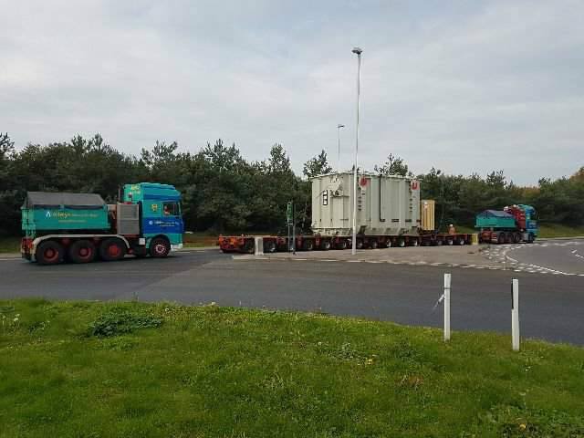
Vehicles may include those used to transport transformers such in 2017 to Richborough for the Nemo Link project – the laying of high voltage electricity cables under the sea between the former Ricborough Towers site and Herdersbrug in Belgium.
There will also be a temporary bridge over the River Stour.
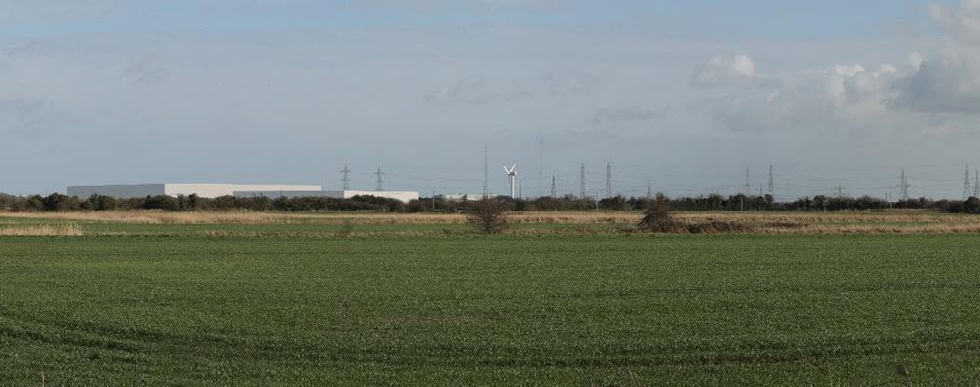
Kent Wildlife Trust is asking members of the public to register as Interested Parties in the process so they can highlight concerns around damage to Pegwell Bay and Minster Marshes.
Campaigners have created a step-by-step guide to assist people in navigating the system in a bid to help them engage with the process. Once registrations open, the public and organisation will have 30 days to sign up.
The full application is available to view on the dedicated Sea Link page of the Planning Inspectorate website.
Find the Rethink Sea Link campaign here

“National Grid says demand for energy is increasing”.
Where exactly is this demand coming from? Are we all becoming lazier and greedier for instant energy? Or is the National Grid trying to put words into our mouths so the suppliers can bleed extra profits from us?
It’s all fake news from Nat Grid. Collective demand for energy is actually falling due to the spiralling costs. We are learning to cope WITHOUT the luxury of surplus energy
Any bets the NIMBYs will be out in force. The grid needs upgrading to deal with the more distributed production of electricity from renewable vs traditional fossils fuel plants. Couple that with the increased demand due to electrification and it all makes sense. Get on and build it.
No doubt the greens will be all against it. Just as they were with HS2. How ironic.
Jane, it’s not just the so-called NIMBYs who will object. Loads of wildlife species are against this too. Honestly, they behave as though they were on this planet longer than the capitalists!
And what the hell do THEY know about the demand for electricity? They don’t even own air conditioning units, freezers, dishwashers or tumble dryers. They’re worse than luddites eh?